Groundwater Survey Before Borewell Drilling: Why It Matters
Planning to drill a borewell? It might seem like the obvious next step when you need a dependable water source, but drilling without understanding what lies beneath the ground can be an expensive mistake.
Every piece of land is different. Some locations have strong groundwater potential, while others may require deeper drilling or may not produce enough water at all.
This is where a Groundwater Survey becomes essential. Instead of relying on assumptions or traditional methods, a scientific survey helps identify the best possible location for drilling based on geological data. Companies like Bhoojal Survey use modern survey techniques to provide reliable information that supports better decision-making before drilling begins.
In this guide, we'll explain why groundwater surveys matter, how they work, and how they can save you both time and money.
Why a Groundwater Survey Is Important Before Borewell Drilling
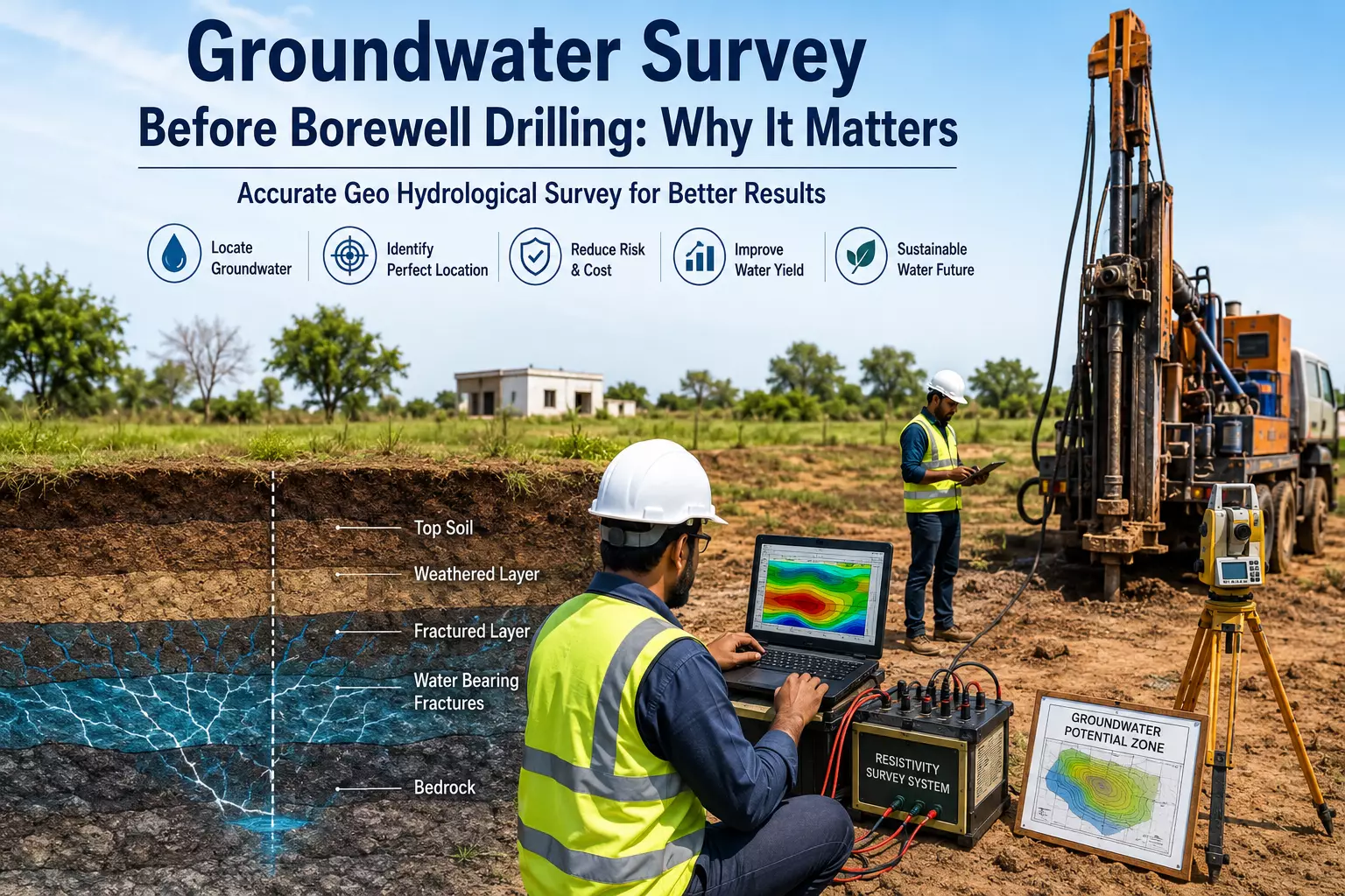
A Groundwater Survey is a scientific assessment of underground geological conditions to determine the most suitable location for a borewell. It helps experts identify water-bearing formations, estimate drilling depth, and evaluate groundwater availability.
Many people believe drilling is simply about finding water beneath the surface. In reality, groundwater exists in specific geological formations, fractures, and aquifers. Without proper investigation, the chances of drilling a low-yield or dry borewell increase significantly.
Conducting a survey first provides valuable information that improves planning and reduces unnecessary risks.
What Happens If You Skip a Groundwater Survey?
Although skipping the survey may seem like a way to reduce upfront costs, it often leads to much higher expenses later.
Dry Borewell
One of the most common outcomes is drilling into an area with little or no groundwater. A failed borewell means the drilling investment may be completely lost.
Higher Drilling Costs
Without scientific data, contractors may drill much deeper than necessary or choose the wrong location entirely, increasing labour and equipment costs.
Poor Water Yield
Even if water is found, it may not provide enough supply for homes, farms, industries, or commercial properties.
Wasted Time
A failed borewell usually means repeating the entire process at another location, delaying your project and increasing overall costs.
How an Accurate Geo Hydrological Survey Improves Borewell Success
An Accurate Geo Hydrological Survey combines geological expertise with advanced technology to understand what exists beneath the surface.
Instead of selecting a drilling point randomly, specialists carefully analyse underground formations and groundwater movement.
Geological Mapping
The survey studies different rock formations to determine where groundwater is most likely to be stored.
Fracture Zone Identification
Groundwater often collects within fractured rock layers. Detecting these zones significantly improves drilling accuracy.
Electrical Resistivity Survey
Electrical resistivity testing measures how underground materials respond to electrical current. Since water-bearing formations have different resistivity values than dry rocks, this technique helps identify potential groundwater zones.
Surface Analysis
Experts also evaluate slope, drainage patterns, nearby water bodies, and soil characteristics before recommending a drilling location.
Using these combined methods, Bhoojal Survey helps clients make informed decisions based on scientific observations rather than guesswork.
HyGroundwaterdrogeological Survey to Locate
A Hydrogeological Survey to Locate Groundwater goes beyond simply identifying where water might be present. It examines the complete groundwater system beneath the land.
Understanding Aquifers
Hydrogeologists identify aquifers capable of storing and supplying groundwater over long periods.
Groundwater Recharge
The survey evaluates whether rainfall and surrounding conditions naturally replenish groundwater throughout the year.
Seasonal Changes
Groundwater levels often rise during the monsoon and fall during summer. Understanding these seasonal variations helps improve borewell planning.
Sustainable Water Management
The goal isn't just to locate groundwater but also to recommend drilling practices that support long-term water availability.
This scientific approach allows property owners to make better investment decisions while promoting responsible groundwater use.
Who Needs a Groundwater Survey?
A professional survey is valuable for many different projects.
Residential Properties
Homeowners planning private borewells can reduce the risk of unsuccessful drilling.
Agriculture
Farmers depend heavily on groundwater for irrigation. Choosing the right drilling location improves water availability for crops.
Commercial Buildings
Hotels, schools, hospitals, offices, and shopping complexes require dependable water supplies for daily operations.
Industries
Manufacturing units often need large quantities of water. A survey helps ensure better planning before investing in drilling.
Real Estate Projects
Builders frequently conduct groundwater investigations before construction to ensure adequate water resources for future occupants.
Benefits of Conducting a Groundwater Survey
Investing in a professional survey offers several long-term advantages.
Better Planning
Scientific data allows property owners to make informed decisions before drilling begins.
Reduced Financial Risk
Avoiding failed borewells often saves far more money than the survey itself costs.
Improved Drilling Accuracy
Knowing the expected drilling depth and recommended location increases operational efficiency.
Reliable Information
A professional survey provides evidence-based recommendations rather than assumptions.
Sustainable Water Use
Understanding groundwater conditions helps support responsible extraction and long-term resource management.
Read: Complete Guide to Waterproofing Membrane Sheet in Lahore for
Modern Technology Has Improved Groundwater Investigation
Groundwater exploration has changed dramatically over the past decade.
Today's surveys often combine:
- Electrical Resistivity Surveys
- GPS Mapping
- GIS Technology
- Satellite Image Analysis
- Geological Mapping
- Digital Data Interpretation
By integrating multiple technologies, companies such as Bhoojal Survey provide more comprehensive assessments of underground conditions than traditional methods alone.
Although no technology can guarantee groundwater at every location, modern survey methods greatly improve the chances of selecting a productive drilling site.
Choosing the Right Survey Partner
Not every survey provider offers the same level of expertise.
Before hiring a company, consider:
Experience
Choose professionals with proven expertise in groundwater investigations.
Modern Equipment
Advanced instruments generally provide more accurate field data.
Qualified Experts
Hydrogeologists and geophysicists should be involved in interpreting survey results.
Detailed Reporting
A good survey report explains findings clearly and includes practical recommendations.
Local Geological Knowledge
Understanding regional geology plays an important role in groundwater assessment.
Working with experienced professionals like Bhoojal Survey ensures that survey recommendations are based on scientific analysis and practical field experience.
Conclusion
A Groundwater Survey is one of the most important steps before borewell drilling. It helps identify suitable drilling locations, estimates groundwater potential, and reduces the risk of costly mistakes.
Whether you're a homeowner, farmer, builder, or industrial project manager, investing in a professional survey provides valuable insights before significant drilling expenses are incurred.
An Accurate Geo Hydrological Survey uses modern techniques to analyse underground formations and improve borewell planning, while a Hydrogeological Survey to Locate Groundwater helps assess aquifers, recharge potential, and long-term water availability.
If you're planning a borewell project, consulting experts such as Bhoojal Survey can help you make informed decisions based on scientific data, improving your chances of a successful and sustainable water source.
Frequently Asked Questions (FAQs)
1. Why is a Groundwater Survey necessary before borewell drilling?
A Groundwater Survey helps identify suitable drilling locations, estimates groundwater depth, and reduces the risk of drilling a dry or low-yield borewell.
2. What is an Accurate Geo Hydrological Survey?
An Accurate Geo Hydrological Survey combines geological mapping, resistivity testing, and field observations to locate promising groundwater-bearing formations before drilling.
3. What is a Hydrogeological Survey to Locate Groundwater?
A Hydrogeological Survey to Locate Groundwater studies aquifers, groundwater movement, recharge potential, and geological formations to recommend the best drilling location.
4. Can a groundwater survey guarantee water?
No. A survey cannot guarantee groundwater because natural conditions vary, but it significantly improves the likelihood of selecting a productive drilling site using scientific methods.
5. Who should conduct a groundwater survey?
Groundwater surveys are recommended for homeowners, farmers, industries, commercial buildings, institutions, and real estate developers planning to install a borewell or secure a reliable water source.